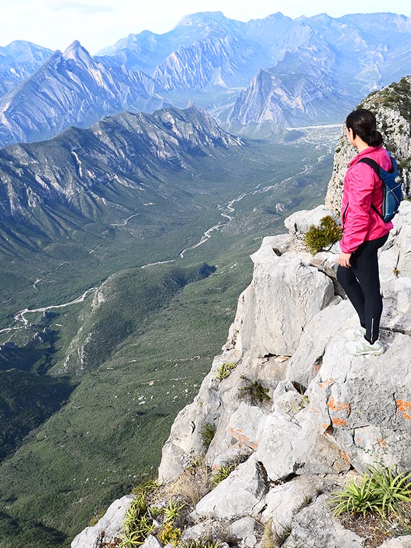
The “M” summit has an altitude of 2030 masl (meters avobe sea level) and it is the second highest among the 3 summits at Chipinque ecological park (“Copete”, “Antena”, “M”). It is located in San Pedro, Garza García, Nuevo León, México, only 15 minutes away from the Monterrey metropolitan área, on the limits of the Sierra Madre mountain range. The route offers a spectacular view full of contrasts. On one side it is possible to admire the Cerro de la Silla mountain, symbol of the city, on the other, the majestic mountain range of the PNCM (Cumbres de Monterrey National Park).
Route Description
Start time: 6:00 am
Activity: Hiking
Horizontal ascent distance: 3.9 km
Horizontal descent distance: 3.9 km
Minimum altitude: 1,270 masl
Maximum altitude: 2,030 masl
Altitude change: 760 meters
Duration: 8 a 9 hours
Ascent time: 4:00 hours *.
Peak time: 30 minutes *.
Descent time: 3:30 hours *.
* Average time per group
Difficulty : Moderate / Challenging
Moderate: Accessible for all those in good health, who do a little sport regularly, and who are accustomed to walking on all types of terrain. 4 – 6 hours of walking per day, without much weight to carry.
Challenging: For those physically active and who have some experience in traveling in mountainous terrain with a backpack. 6 – 7 hours of hiking per day.
Route
MESETA – FORK
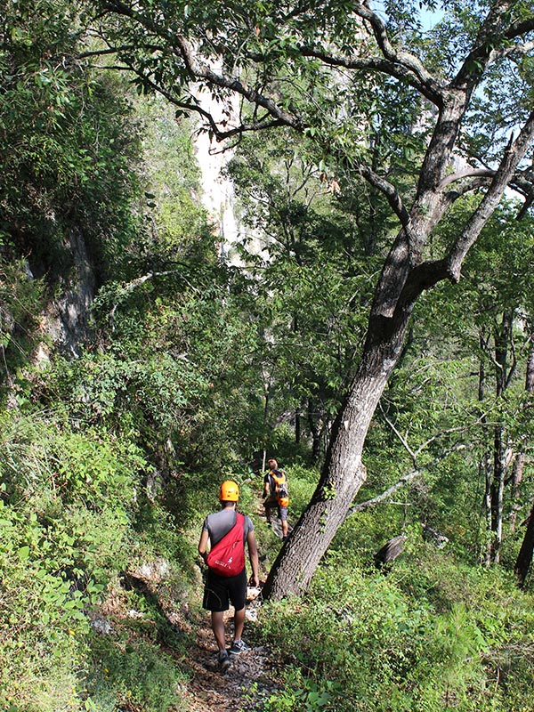
The route starts at the “Meseta” parking lot and towards the trailhead heading towards the “M”, “ventana”, and “antenas”. The first part of the trail is a relatively easy hike for approximately 1.5 Kms. Further ahead, the trail starts gaining more inclination and going up in a series of zig-zags that cross a dry creek in various points. The trail eventually comes to a fork dividing the trails that go towards the “Ventana” and “Antenas” on one side, and towards the “M” on the other side.
FORK – CHORREADERO
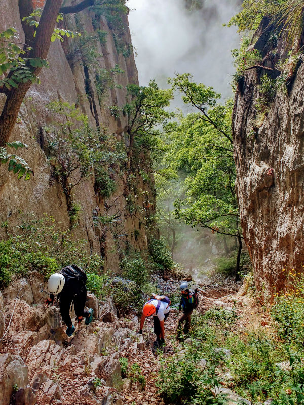
At the fork, we take the Trail heading to the west towards the “M”. This part of the Trail combines uphill and downhill sections until it gets to a narrow pass between two rock walls offering a beautiful scene. After crossing the pass, the uphill and downhill sections continue until reaching the “chorreadero”, a steep ravine with loose rocks and dirt. After this section, the use of a helmet is encouraged, and it is of utter importance to have your hands free to be able to hold on to the cables set up on the sides for aiding in the ascent..
CHORREADERO – SUMMIT
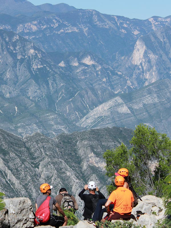
On exiting the “chorreadero” the Trail hits the Edge offering a spectacular scenic view. To the South, one can see the greatness of the Sierra Madre mountain range; to the West the “Huasteca” and “La Calle” mountain; to the East the rest of Chipinque’s summits: “Antenas”, “Ventana”, and “Copete de las Águilas”, and the Saddle Mountain; to the North “Mitras” and “Topo Chico” mountains.
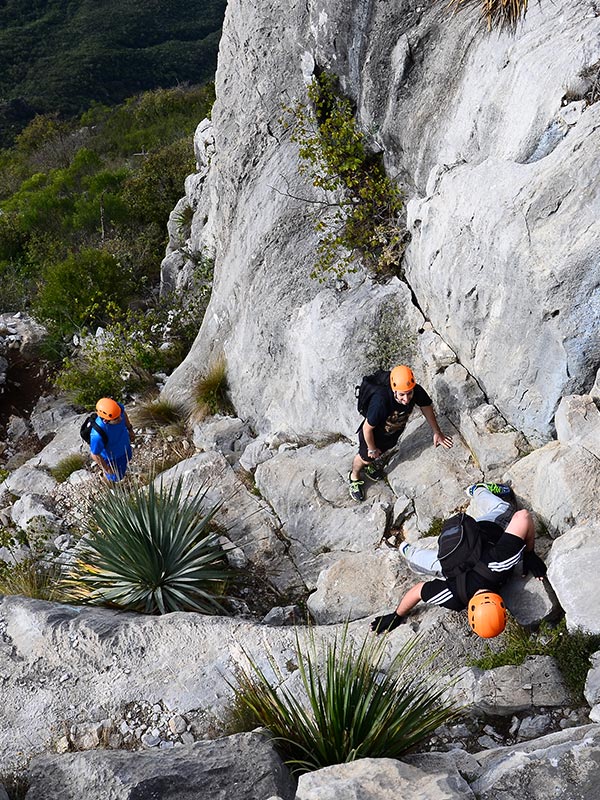
The next part, between the “chorreadero” and the Summit, requires more dexterity since it involves scrambling over big boulders. It is recommended to wear a helmet and gloves to protect head and hands. The scrambling is not hard since there are good handholds and the terrain is not completely vertical. Yet, it is important to be careful and maintain hands free. Just before the summit, there is a false summit and it is necessary to descend a bit and cross a narrow port to then scramble over the boulders in the last section heading westward, towards the cross that marks the summit.
REGRESO
The route back follows the same Trail used to go up. It is important to consider the accumulated fatigue and take all precautions in the scrambling sections. When going down over these sections, it is recommended to face towards the rocks, especially if wearing a backpack. If necessary, the descent can be aided by a rope and a herness.
AVAILABLE DATES
Saturday – April 28th
Saturday – June 2nd
Sunday – August 12th
Saturday – October 27th
Saturday – December 15th
Clothing and equipment
-
Hiking boots or shoes
- Dryfit pants or shorts
- Dryfit shirt
- Windstop jacket
- Backpack 20L
- Fruit or vegetables (apple, grapes, orange, jicama, etc.)
- Trail mix (nuts, almonds, peanuts, etc.)
- Energy or granola bar
- Sandwich and/or lunch
- 1 liter of water
- 1 liter of isotonic drink
- Sunscreen
Optional
- Trekking poles
- Gym gloves
- Headlamp
- Sunglasses with UV protection
- Buff and/or cap
- Lip balm
- Extra shirt
- Extra pair of socks
- Wet wipes
- Plastic bag
PNCM
PNCM (Cumbres de Monterrey National Park)
PNCM (Cumbres de Monterrey National Park)
Guidelines to follow
- Cover the fees established in the Federal Rights Law.
- Light fires only in the areas designated for that purpose and with the precautionary measures dictated by the park administration.
- Do not leave materials that imply fire risks in the area visited.
- Do not alter the order and conditions of the site visited such as: noise disturbances, disturbing animals, cutting plants, extracting fossils or archaeological objects, or altering sites with historical and cultural value.
- No smoking inside the park.
- No feeding native fauna.
- No pets allowed.
- The solid waste generated by the visitors in any part of the park, should be collected by the users and carried out with them in order not to leave them on site.
- The garbage generated inside the park must be deposited outside the park.
- Respect the established routes and paths within the park.
- Provide data requested for knowledge and statistics and facilitate the development of inspection or surveillance activities carried out by Park staff.
- Respect and attend to the indications made by Park staff.
- Unmanned aerial vehicles are not allowed in the park, including drones in all areas of the park.